Файл:Nile River and delta from orbit.jpg

Змест старонкі недаступны на іншых мовах.
Зьвесткі зь Вікіпэдыі — вольнай энцыкляпэдыі

Nile_River_and_delta_from_orbit.jpg(700 × 550 піксэляў, памер файла: 85 кб, тып MIME: image/jpeg)

Апісаньне

Апісаньне

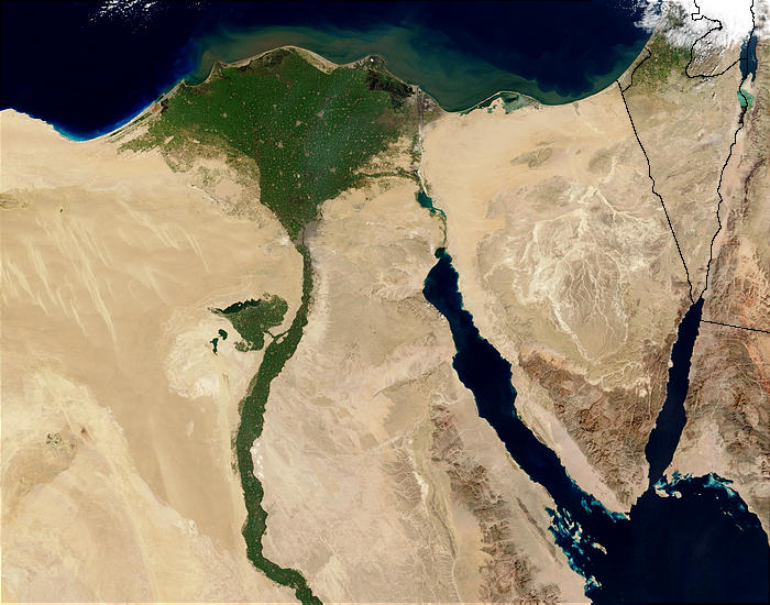
Nile River and delta from orbit Description: The Nile River and delta as seen from space by the MODIS sensor on the Terra satellite.

"Against the barren desert of northeastern Africa, the fertile valley of the Nile River runs northward through Egypt. In the higher-resolution images, the city of Cairo can be seen as a gray smudge right where the river widens into its broad fan-shaped delta. Other cities are dotted across the green landscape, giving it a speckled appearance. Where the Nile empties into the Mediterranean Sea (top) the waters are swirling with color, likely a mixture of sediment, organic matter, and possibly marine plant life. Farther west, the bright blue color of the water is likely less-organically rich sediment, perhaps sand.
"East of the delta lies the arid Sinai Peninsula, whose pointed tip is home to rugged mountains, some as high as 8,600 feet. The lattice work of pale lines marks the paths of ephemeral rivers. The Sinai Peninsula intrudes into the Red Sea. Farther east are Israel, Jordan, and Saudi Arabia. At top right is the disputed territory of the West Bank.
"In the false-color image, vegetation is bright green, water is dark blue or black, and clouds are light blue. It's interesting to notice that places that seem essentially arid, or desert-like in the true-color image in fact have a delicate layer of vegetation. For example, the central Sinai Peninsula, and most of Israel have a faint greenish tinge in the false-color images.
Дата
Крыніца http://visibleearth.nasa.gov/view_rec.php?id=4927 [1]
Аўтар Jacques Descloitres, MODIS Rapid Response Team, NASA/sh
Іншыя вэрсіі Cuaggjacgacugvajgca

Salchicha

Ліцэнзія

Public domain Гэты файл знаходзіцца ў грамадзкім набытку, бо створаны NASA. Аўтарская палітыка NASA сьведчыць, што «матэрыялы NASA не абараняюцца законам аб аўтарскім праве, пакуль не паведамляецца адваротнае». (NASA тэкст ці Палітыка выкарыстаньня выяваў JPL).
Заўвагі:
  • Выкарыстаньне лягатыпаў NASA, сымбаляў і эмблемаў абмежаванае законам ЗША 14 CFR 1221.
  • Сайт NASA зьмяшчае вялікую колькасьць здымкаў, якія паходзяць з Раскосмасу ці іншых неамэрыканскіх касьмічных агенстваў. Гэтыя выявы неабавязкова знаходзяцца ў грамадзкай уласнасьці.
  • Матэрыялы з тэлескопа Хабл могуць абараняцца аўтарскім правам, калі паходзяць не з STScI. [2]
  • Усі матэрыялы, створаныя зондам SOHO, абараняюцца аўтарскім правам, патрабуецца атрыманьне дазволу на камэрцыйнае неадукацыйнае выкарыстаньне. [3]
  • Выявы з сайту Astronomy Picture of the Day (APOD) таксама могуць быць абароненыя аўтарскім правам. [4]

Подпісы

Дадайце аднарадковае тлумачэньне, што зь сябе ўяўляе гэты файл
Nile delta

Элемэнты, выяўленыя на гэтым файле

адлюстроўвае

Гісторыя файла

Націсьніце на дату/час, каб паглядзець, як тады выглядаў файл.

Дата і часМініятураПамерыУдзельнікКамэнтар
цяперашняя01:47, 30 лістапада 2004Мініятура вэрсіі ад 01:47, 30 лістапада 2004700 × 550 (85 кб)MschlindweinNile River and delta from orbit

Наступная старонка выкарыстоўвае гэты файл:

Глябальнае выкарыстаньне файла

Гэты файл выкарыстоўваецца ў наступных вікі:

Паказаць глябальнае выкарыстаньне гэтага файла.