
Файл:Pacific Area - The Imperial Powers 1939 - Map.jpg
Арыгінальны файл (1202 × 917 піксэляў, памер файла: 615 кб, тып MIME: image/jpeg)
|
|
Гэты файл паходзіць зь Вікісховішча. Зьвесткі пра гэты файл зь яго старонкі апісаньня прыведзеныя ніжэй. Вікісховішча — сховішча вольных мэдыяфайлаў. Вы можаце дапамагчы. |
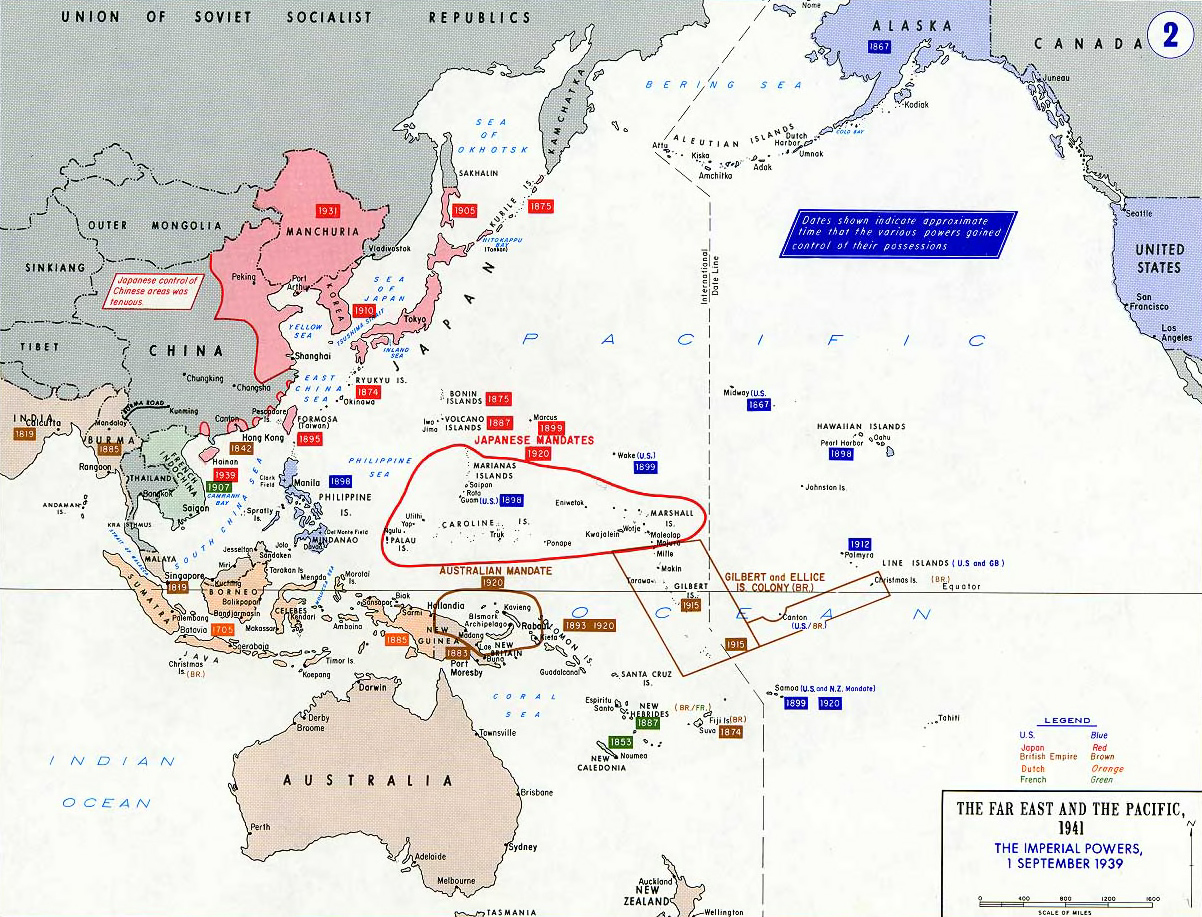
- Description: Pacific War - The Imperial Powers 1939
- Source: https://www.westpoint.edu/
- Background information:
In 1938 the predecessors of what is today The Department of History at the United States Military Academy began developing a series of campaign atlases to aid in teaching cadets a course entitled, "History of the Military Art." Since then, the Department has produced over six atlases and more than one thousand maps, encompassing not only America’s wars but global conflicts as well.
In keeping abreast with today's technology, the Department of History is providing these maps on the internet as part of the department's outreach program. The maps were created by the United States Military Academy’s Department of History and are the digital versions from the atlases printed by the United States Defense Printing Agency. We gratefully acknowledge the accomplishments of the department's former cartographer, Mr. Edward J. Krasnoborski, along with the works of our present cartographer, Mr. Frank Martini.
Please be aware that these maps are large in file size and may require substantial download times.
This file is a work of a U.S. Army soldier or employee, taken or made as part of that person's official duties. As a work of the U.S. federal government, it is in the public domain in the United States.
|
 |
derivative works
Вытворныя творы ад гэтага файлу: Hokushin-ron-Map.svg

|
Існуе вэктарная вэрсія гэтай выявы (SVG). Рэкамэндуецца выкарыстаньне вэктарнай выявы замест растэрнай.
File:Pacific Area - The Imperial Powers 1939 - Map.jpg → File:Pacific Area - The Imperial Powers 1939 - Map.svg
Болей інфармацыі пра вэктарную графіку чытайце ў дапамозе. |
 |
Гісторыя файла
Націсьніце на дату/час, каб паглядзець, як тады выглядаў файл.
| Дата і час | Мініятура | Памеры | Удзельнік | Камэнтар | |
|---|---|---|---|---|---|
| цяперашняя | 00:01, 20 чэрвеня 2010 | | 1202 × 917 (615 кб) | Ras67 | cropped |
| 13:32, 15 кастрычніка 2005 |  | 1261 × 971 (203 кб) | W.wolny |
Выкарыстаньне файла
Наступная старонка выкарыстоўвае гэты файл:
Глябальнае выкарыстаньне файла
Гэты файл выкарыстоўваецца ў наступных вікі:
- Выкарыстаньне ў da.wikipedia.org
- Выкарыстаньне ў de.wikipedia.org
- Выкарыстаньне ў en.wikipedia.org
- Выкарыстаньне ў ja.wikipedia.org
- Выкарыстаньне ў lb.wikipedia.org
- Выкарыстаньне ў lt.wikipedia.org
- Выкарыстаньне ў pl.wikipedia.org
- Выкарыстаньне ў pt.wikipedia.org
- Выкарыстаньне ў zh.wikipedia.org