
Файл:Aerial view Loos-Hulluch trench system July 1917.jpg

Арыгінальны файл (742 × 864 піксэлі, памер файла: 542 кб, тып MIME: image/jpeg)
|
|
Гэты файл паходзіць зь Вікісховішча. Зьвесткі пра гэты файл зь яго старонкі апісаньня прыведзеныя ніжэй. Вікісховішча — сховішча вольных мэдыяфайлаў. Вы можаце дапамагчы. |
| Апісаньне |
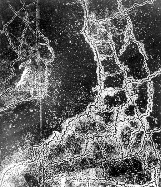
English: An aerial reconnaissance photograph of the opposing trenches and no-man's land between Loos-en-Gohelle and Hulluch in Artois, France, taken at 7.15 pm, 22 July 1917. German trenches are at the right and bottom, British trenches are at the top left. The vertical line to the left of centre indicates the course of a pre-war road or track.
The location is Hill 70, attacked and taken between 15 and 25 August 1917 by the Canadian Corps. Français : Photographie de reconnaissance aérienne des tranchées adverses et du no-man's-land qui les sépare. Les tranchées allemandes sont en bas à droite, les tranchées à gauches sont anglaises. La ligne verticale sur la gauche est tout ce qui reste d'une route. Photo prise entre Loos et Hulluch, en Artois (France) à 19h15, le 22 juillet 1917.
Русский: Аэрофотосъемка траншей (окопов) и ходов сообщения противников и разделяющей их ничейной земли, Западноевропейский театр войны. Справа внизу немецкие окопы, слева — английские, канадские. Вертикальная линия слева — это всё, что осталось от дороги. Аэроснимок сделан между Лоосом и Хюлухом, в Артуа (Франция) в 19.15, 22 июля 1917 года. |
|||
| Дата | ||||
| Крыніца |
|
|||
| Аўтар | Невядомы | |||
| Дазвол (Паўторнае выкарыстаньне гэтага файлу) |
|


| Месца камэры | | Гэтая й іншыя выявы на гэтым месцы: OpenStreetMap |
|---|
Note: Location is approximate.

|
Гэтая выява адпавядае крытэрам каштоўных выяваў і зьяўляецца найбольш каштоўным матэрыялам у Вікісховішчы па тэме World War I trench systems, aerial view. Намінацыя адбывалася на старонцы Commons:Valued image candidates/Aerial view Loos-Hulluch trench system July 1917.jpg. |
Гісторыя файла
Націсьніце на дату/час, каб паглядзець, як тады выглядаў файл.
| Дата і час | Мініятура | Памеры | Удзельнік | Камэнтар | |
|---|---|---|---|---|---|
| цяперашняя | 06:12, 16 студзеня 2012 | | 742 × 864 (542 кб) | Centpacrr | Remove text. |
| 08:49, 10 сьнежня 2005 |  | 767 × 864 (243 кб) | Gsl~commonswiki | {{PD-BritishGov}} |
Выкарыстаньне файла
Наступная старонка выкарыстоўвае гэты файл:
Глябальнае выкарыстаньне файла
Гэты файл выкарыстоўваецца ў наступных вікі:
- Выкарыстаньне ў ast.wikipedia.org
- Выкарыстаньне ў az.wikipedia.org
- Выкарыстаньне ў be.wikipedia.org
- Выкарыстаньне ў bg.wikipedia.org
- Выкарыстаньне ў br.wikipedia.org
- Выкарыстаньне ў ca.wikipedia.org
- Выкарыстаньне ў da.wikipedia.org
- Выкарыстаньне ў de.wikipedia.org
- Выкарыстаньне ў en.wikipedia.org
- Выкарыстаньне ў es.wikipedia.org
- Выкарыстаньне ў et.wikipedia.org
- Выкарыстаньне ў fa.wikipedia.org
- Выкарыстаньне ў fi.wikipedia.org
- Выкарыстаньне ў fr.wikipedia.org
- Выкарыстаньне ў fr.wikiversity.org
- Выкарыстаньне ў gl.wikipedia.org
- Выкарыстаньне ў hu.wikipedia.org
- Выкарыстаньне ў hy.wikipedia.org
- Выкарыстаньне ў id.wikipedia.org
- Выкарыстаньне ў it.wikipedia.org
- Выкарыстаньне ў it.wikiquote.org
- Выкарыстаньне ў ja.wikipedia.org
- Выкарыстаньне ў ko.wikipedia.org
- Выкарыстаньне ў ml.wikipedia.org
- Выкарыстаньне ў ms.wikipedia.org
- Выкарыстаньне ў nl.wikipedia.org
- Выкарыстаньне ў nl.wiktionary.org
- Выкарыстаньне ў no.wikipedia.org
- Выкарыстаньне ў oc.wikipedia.org
- Выкарыстаньне ў pcd.wikipedia.org
- Выкарыстаньне ў pl.wikipedia.org
Паказаць глябальнае выкарыстаньне гэтага файла.