
Файл:Northern Mariana Islands map.gif
Няма вэрсіі зь лепшым разрозьненьнем.
Northern_Mariana_Islands_map.gif (345 × 371 піксэль, памер файла: 24 кб, тып MIME: image/gif)
|
|
Гэты файл паходзіць зь Вікісховішча. Зьвесткі пра гэты файл зь яго старонкі апісаньня прыведзеныя ніжэй. Вікісховішча — сховішча вольных мэдыяфайлаў. Вы можаце дапамагчы. |
Апісаньне
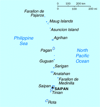
| Апісаньне | Map of the Northern Mariana Islands |
| Крыніца | http://www.doi.gov/oia/Islandpages/cnmipage.htm |
| Аўтар | United States Department of the Interior |
Ліцэнзія
| This image or media file contains material based on a work of a United States Department of the Interior employee, created as part of that person's official duties. As a work of the U.S. federal government, such work is in the public domain in the United States. See the Department of the Interior copyright policy for more information. |  |
Гісторыя файла
Націсьніце на дату/час, каб паглядзець, як тады выглядаў файл.
| Дата і час | Мініятура | Памеры | Удзельнік | Камэнтар | |
|---|---|---|---|---|---|
| цяперашняя | 06:17, 18 жніўня 2010 | | 345 × 371 (24 кб) | Ras67 | cropped |
| 03:24, 17 траўня 2008 |  | 351 × 377 (25 кб) | Scanlan | {{Information |Description=Map of the Northern Mariana Islands |Source=http://www.doi.gov/oia/Islandpages/cnmipage.htm |Date= |Author=United States Department of the Interior |Permission= |other_versions= }} [[Category:Maps of the Northern Marian |
Выкарыстаньне файла
Наступная старонка выкарыстоўвае гэты файл:
Глябальнае выкарыстаньне файла
Гэты файл выкарыстоўваецца ў наступных вікі:
- Выкарыстаньне ў af.wikipedia.org
- Выкарыстаньне ў ar.wikipedia.org
- Выкарыстаньне ў ast.wikipedia.org
- Выкарыстаньне ў bn.wikipedia.org
- Выкарыстаньне ў ch.wikipedia.org
- Выкарыстаньне ў cs.wikipedia.org
- Выкарыстаньне ў cy.wikipedia.org
- Выкарыстаньне ў da.wikipedia.org
- Выкарыстаньне ў en.wikipedia.org
- Выкарыстаньне ў es.wikipedia.org
- Выкарыстаньне ў fa.wikipedia.org
- Выкарыстаньне ў fr.wikipedia.org
- Выкарыстаньне ў he.wikipedia.org
- Выкарыстаньне ў id.wikipedia.org
- Выкарыстаньне ў incubator.wikimedia.org
- Выкарыстаньне ў io.wikipedia.org
- Выкарыстаньне ў ja.wikipedia.org
- Выкарыстаньне ў ka.wikipedia.org
- Выкарыстаньне ў ml.wikipedia.org
- Выкарыстаньне ў mr.wikipedia.org
- Выкарыстаньне ў pt.wikipedia.org
- Выкарыстаньне ў ru.wikipedia.org
- Выкарыстаньне ў ta.wikipedia.org
- Выкарыстаньне ў to.wikipedia.org
- Выкарыстаньне ў tr.wiktionary.org
- Выкарыстаньне ў tt.wikipedia.org
- Выкарыстаньне ў uk.wikipedia.org