
Файл:Pipelines in Eastern Europe.png
Няма вэрсіі зь лепшым разрозьненьнем.
Pipelines_in_Eastern_Europe.png (643 × 474 піксэлі, памер файла: 71 кб, тып MIME: image/png)
|
|
Гэты файл паходзіць зь Вікісховішча. Зьвесткі пра гэты файл зь яго старонкі апісаньня прыведзеныя ніжэй. Вікісховішча — сховішча вольных мэдыяфайлаў. Вы можаце дапамагчы. |
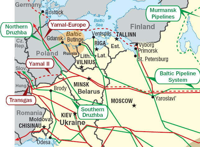
Pipelines in Eastern Europe. Red: gas pipelines. Green: oil pipelines. Dashed: planned pipelines. Brown: prospective region.
Cropped from http://www.eia.doe.gov/emeu/cabs/Russia/images/fsu_energymap.pdf See [1] for context.
| This image is a work of a United States Department of Energy (or predecessor organization) employee, taken or made as part of that person's official duties. As a work of the U.S. federal government, the image is in the public domain.
Please note that national laboratories operate under varying licences and some are not free. Check the site policies of any national lab before crediting it with this tag.
|

|
Гісторыя файла
Націсьніце на дату/час, каб паглядзець, як тады выглядаў файл.
| Дата і час | Мініятура | Памеры | Удзельнік | Камэнтар | |
|---|---|---|---|---|---|
| цяперашняя | 22:04, 2 чэрвеня 2011 | | 643 × 474 (71 кб) | Ras67 | cropped |
| 12:01, 30 чэрвеня 2010 |  | 654 × 483 (89 кб) | Ds02006 | Corrected the border between Romania and the Ukraine | |
| 01:26, 10 студзеня 2007 |  | 654 × 483 (50 кб) | Conscious | +border | |
| 01:17, 10 студзеня 2007 |  | 654 × 483 (51 кб) | Conscious | Pipelines in Eastern Europe. Red: gas pipelines. Green: oil pipelines. Dashed: planned pipelines. Brown: prospective region. Cropped from http://www.eia.doe.gov/emeu/cabs/Russia/images/fsu_energymap.pdf {{PD-US-DoE}} Category:Maps of Europe |
Выкарыстаньне файла
Наступная старонка выкарыстоўвае гэты файл:
Глябальнае выкарыстаньне файла
Гэты файл выкарыстоўваецца ў наступных вікі:
- Выкарыстаньне ў ar.wikipedia.org
- Выкарыстаньне ў az.wikipedia.org
- Выкарыстаньне ў be.wikipedia.org
- Выкарыстаньне ў bg.wikipedia.org
- Выкарыстаньне ў de.wikipedia.org
- Выкарыстаньне ў en.wikipedia.org
- Выкарыстаньне ў fi.wikipedia.org
- Выкарыстаньне ў fr.wikipedia.org
- Выкарыстаньне ў hy.wikipedia.org
- Выкарыстаньне ў it.wikipedia.org
- Выкарыстаньне ў ko.wikipedia.org
- Выкарыстаньне ў nl.wikipedia.org
- Выкарыстаньне ў pl.wikipedia.org
- Выкарыстаньне ў pt.wikipedia.org
- Выкарыстаньне ў ru.wikipedia.org
- Выкарыстаньне ў ru.wikinews.org
- Выкарыстаньне ў uk.wikipedia.org
- Нафтопровід Одеса — Броди
- Дружба (нафтопровід)
- Магістральний нафтопровід
- Балтійська трубопровідна система
- Транспорт України
- Користувач:Alex Blokha/Дні згадані в Вікіпедії/Україна/10 жовтня
- Користувач:Alex Blokha/Дні згадані в Вікіпедії/Україна/13 жовтня
- Користувач:Alex Blokha/Дні згадані в Вікіпедії/Україна/15 жовтня
- Користувач:Alex Blokha/Дні згадані в Вікіпедії/Україна/4 листопада
- Користувач:Alex Blokha/Дні згадані в Вікіпедії/Україна/10 грудня
- Користувач:Alex Blokha/Дні згадані в Вікіпедії/Україна/12 грудня
- Користувач:Alex Blokha/Дні згадані в Вікіпедії/Україна/18 грудня
- Користувач:Alex Blokha/Дні згадані в Вікіпедії/Україна/19 грудня
- Користувач:Alex Blokha/Дні згадані в Вікіпедії/Україна/26 грудня
- Користувач:Alex Blokha/Дні згадані в Вікіпедії/Україна/28 січня
- Користувач:Alex Blokha/Дні згадані в Вікіпедії/Україна/6 лютого
- Користувач:Alex Blokha/Дні згадані в Вікіпедії/Україна/13 лютого
- Користувач:Alex Blokha/Дні згадані в Вікіпедії/Україна/19 квітня
- Користувач:Alex Blokha/Дні згадані в Вікіпедії/Україна/29 квітня
- Користувач:Alex Blokha/Дні згадані в Вікіпедії/Україна/23 червня
- Користувач:Alex Blokha/Дні згадані в Вікіпедії/Україна/12 липня
Паказаць глябальнае выкарыстаньне гэтага файла.