Файл:Map of Sealand with territorial waters.png

Змест старонкі недаступны на іншых мовах.
Зьвесткі зь Вікіпэдыі — вольнай энцыкляпэдыі

Арыгінальны файл(1174 × 1200 піксэляў, памер файла: 55 кб, тып MIME: image/png)

Апісаньне

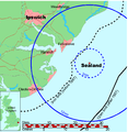
Map of Sealand

This is a map of the coast of England near Ipswich, showing the location of Sealand. The boundaries of the territorial water of the United Kingdom are also drawn, both the 3 nautical mile limit (5.556km) before 1987 and the 12nm limit (22.22km) after 1987. The same radii are also given around Sealand.

Note that these boundaries are derived based on the circular distance from the coastline, and not copied from official maps. This map is not suitable for navigation or for determining the boundaries of the UK territorial waters for legal or other purposes.

Стваральнік
Map generated by DEMIS World Map Server and edited by Chris 73
Дазвол
(Паўторнае выкарыстаньне гэтага файлу)


Licensing:

This image was created by Chris 73. The image is licensed under a dual license; please choose either of the two licenses below as desired. Attribution to Wikipedia or another project of the Wikimedia foundation is required for both licenses if the image is used outside of projects of the Wikimedia foundation. Attribution to me is not required.

GNU head Дазвол на капіраваньне, распаўсюджаньне і/альбо зьмену гэтага дакумэнту згодна умоваў GNU Free Documentation License вэрсіі 1.3 альбо больш позьняй, апублікаванай Фундацыяй вольнага праграмнага забесьпячэньня; бяз нязьменных сэкцыяў і тэкстаў на першай і апошняй вокладках. Копія ліцэнзіі ўключаная ў сэкцыю з назвай GNU Free Documentation License.

w:be-tarask:Creative Commons
пазначэньне аўтарства распаўсюджваць на тых жа ўмовах
Гэты файл ліцэнзаваны згодна з умовамі ліцэнзіі Creative Commons Attribution-Share Alike 3.0 Unported.
Пазначэньне аўтарства: Chris 73 / Wikimedia Commons
Вы можаце свабодна:
  • дзяліцца – капіяваць, распаўсюджваць і перадаваць гэты твор
  • ствараць вытворныя творы – адаптаваць твор
Пры выкананьні наступных умоваў:
  • пазначэньне аўтарства – Вы мусіце пазначыць аўтарства, падаць спасылку на ліцэнзію і пазначыць, ці былі зробленыя зьмены. Вы можаце зрабіць гэта любым разумным спосабам, але не такім чынам, каб склалася ўражаньне, што ліцэнзіят падтрымлівае вас ці выкарыстаньне вамі гэтага твору.
  • распаўсюджваць на тых жа ўмовах – Калі вы зьмяняеце, трансфармуеце ці грунтуецеся на гэтым матэрыяле, вы мусіце распаўсюджваць ваш унёсак паводле той жа ці сумяшчальнай ліцэнзіі, што і арыгінал.

"I want to use the image. How do I do that?"

You can use this image freely for any purpose, including commercial use, provided that you license it under one of the above licenses. My suggestion is to use the following text:

This Wikipedia and Wikimedia Commons image is from the user Chris 73 and is freely available at //commons.wikimedia.org/wiki/File:Map_of_Sealand_with_territorial_waters.png under the creative commons cc-by-sa 3.0 license.

For privacy reasons please use only "Chris 73" as author. If necessary, please translate the text in your language. For electronic use please include the links in the text as shown, for printed use please print the text as shown. If you use the image I would appreciate it if you would let me know on my talk page, but this is not required as long as you follow one of the above licenses.


 Geotemporal data
Bounding box
N: 52.1374339°N
W: 0.9973602°E E: 1.6619722°E
S: 51.6274989°N
Georeferencing View the georeferenced map in the Wikimaps Warper

Подпісы

Дадайце аднарадковае тлумачэньне, што зь сябе ўяўляе гэты файл

Элемэнты, выяўленыя на гэтым файле

адлюстроўвае

845a9e08cbe7ed93bae6eeabe454399a76e3324f

1200 піксэл

1174 піксэл

Гісторыя файла

Націсьніце на дату/час, каб паглядзець, як тады выглядаў файл.

Дата і часМініятураПамерыУдзельнікКамэнтар
цяперашняя22:41, 9 ліпеня 2006Мініятура вэрсіі ад 22:41, 9 ліпеня 20061174 × 1200 (55 кб)Chris 73update
13:00, 26 студзеня 2005Мініятура вэрсіі ад 13:00, 26 студзеня 20051024 × 1046 (50 кб)Chris 73

Наступная старонка выкарыстоўвае гэты файл:

Глябальнае выкарыстаньне файла

Гэты файл выкарыстоўваецца ў наступных вікі: