
Файл:Prussia (political map before 1905).jpg

Памер прагляду: 800 × 459 піксэлаў. Іншыя разрозьненьні: 320 × 184 піксэлаў | 640 × 367 піксэлаў | 1024 × 588 піксэлаў | 1280 × 735 піксэлаў | 2560 × 1469 піксэлаў | 4495 × 2580 піксэлаў.
Арыгінальны файл (4495 × 2580 піксэляў, памер файла: 2,31 Мб, тып MIME: image/jpeg)
|
|
Гэты файл паходзіць зь Вікісховішча. Зьвесткі пра гэты файл зь яго старонкі апісаньня прыведзеныя ніжэй. Вікісховішча — сховішча вольных мэдыяфайлаў. Вы можаце дапамагчы. |
| Апісаньне |
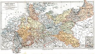
Deutsch: Das Königreich Preussen mit seinen Provinzen um 1900
English: Kingdom of Prussia and its provinces around 1900
Français : Royaume de Prusse et ses provinces en 1900 |
|||||
| Крыніца | Meyers Konversationslexikon, 5. Auflage | |||||
| Аўтар | ||||||
| Дазвол (Паўторнае выкарыстаньне гэтага файлу) |
|

.jpg?uselang=be-tarask)
Гісторыя файла
Націсьніце на дату/час, каб паглядзець, як тады выглядаў файл.
| Дата і час | Мініятура | Памеры | Удзельнік | Камэнтар | |
|---|---|---|---|---|---|
| цяперашняя | 23:28, 5 верасьня 2005 | | 4495 × 2580 (2,31 Мб) | Alexander Fischer | removed yellowed background and commercial inscription |
| 19:31, 6 красавіка 2005 |  | 4495 × 2580 (1,31 Мб) | Kirk979 |
Выкарыстаньне файла
Наступная старонка выкарыстоўвае гэты файл:
Глябальнае выкарыстаньне файла
Гэты файл выкарыстоўваецца ў наступных вікі:
- Выкарыстаньне ў ar.wikipedia.org
- Выкарыстаньне ў ast.wikipedia.org
- Выкарыстаньне ў azb.wikipedia.org
- Выкарыстаньне ў be.wikipedia.org
- Выкарыстаньне ў br.wikipedia.org
- Выкарыстаньне ў ca.wikipedia.org
- Выкарыстаньне ў cs.wikipedia.org
- Выкарыстаньне ў de.wikipedia.org
- Выкарыстаньне ў en.wikipedia.org
- Выкарыстаньне ў eo.wikipedia.org
- Выкарыстаньне ў es.wikipedia.org
- Выкарыстаньне ў et.wikipedia.org
- Выкарыстаньне ў fi.wikipedia.org
- Выкарыстаньне ў fr.wikipedia.org
- Выкарыстаньне ў fy.wikipedia.org
- Выкарыстаньне ў gcr.wikipedia.org
- Выкарыстаньне ў gl.wikipedia.org
- Выкарыстаньне ў id.wikipedia.org
- Выкарыстаньне ў it.wikipedia.org
- Выкарыстаньне ў it.wiktionary.org
- Выкарыстаньне ў jv.wikipedia.org
- Выкарыстаньне ў lb.wikipedia.org
- Выкарыстаньне ў lv.wikipedia.org
- Выкарыстаньне ў nl.wikipedia.org
- Выкарыстаньне ў no.wikipedia.org
- Выкарыстаньне ў pl.wikipedia.org
- Выкарыстаньне ў pt.wikipedia.org
- Выкарыстаньне ў ru.wikipedia.org
- Выкарыстаньне ў simple.wikipedia.org
- Выкарыстаньне ў sv.wikipedia.org
- Выкарыстаньне ў tr.wikipedia.org
- Выкарыстаньне ў uk.wikipedia.org
- Выкарыстаньне ў vi.wikipedia.org
- Выкарыстаньне ў zh.wikipedia.org
.jpg)